

By Global Seismic Desk
Published: 2026
Main Facts
In 2026, the northern region of South America became the epicenter of a compelling and intensely studied seismic phenomenon. Two high-magnitude earthquakes struck Colombia and Venezuela, capturing the attention of international seismologists, geologists, and the general public. While the numerical values on the Richter and moment magnitude scales appeared closely matched, the physical mechanics, depth profiles, structural impacts, and tectonic behaviors of these two events could hardly have been more different.
The first major event occurred on a Monday morning when a staggering 7.4-magnitude earthquake struck San José del Palmar, in the Chocó department of Colombia, at precisely 7:34 a.m. This powerful convulsion represented a singular, massive mainshock characterized by a deep-focus origin—pegged at 103 kilometers beneath the surface—which subsequently triggered an active sequence of aftershocks across the region. According to the Colombian Geological Service (Servicio Geológico Colombiano – SGC), this singular event etched its name into the history books as the most powerful earthquake recorded in Colombia during the 21st century, and the strongest seismic event felt nationwide in the last decade.
In stark contrast, Venezuela’s seismic ordeal unfolded as a textbook geological anomaly. Rather than experiencing a traditional mainshock followed by a gradual decay of aftershocks, the earth in Venezuela ruptured in an exceptional sequence on June 24. A primary tremor measuring magnitude 7.2 was followed a mere 39 seconds later by a secondary, even more violent 7.5-magnitude shock. Geologists classified this rare occurrence as a seismic "doublet"—a phenomenon where two distinct, major fault ruptures occur in rapid succession, overwhelming the lithosphere and delivering a punishing double-blow to the affected population.
Chronology
The Colombian Event: Monday Morning in Chocó
The timeline of the Colombian seismic crisis began abruptly at 7:34 a.m. on a Monday. The sudden rupture centered on the remote and rugged terrain of San José del Palmar in Chocó, catching millions of citizens off guard as shaking rippled across multiple departments, including major urban centers far from the epicenter.
As the morning progressed, the SGC’s monitoring networks went into overdrive. By midday, just a few hours after the initial cataclysm, scientists had already documented 18 distinct aftershocks. These subsequent tremors were primarily concentrated around San José del Palmar and the neighboring municipality of Sipí, registering magnitudes ranging from a minor 1.4 to a rattling 4.8. Seismologists quickly issued advisories noting that due to the immense scale of the 7.4 mainshock, these aftershocks would likely persist for days, weeks, or potentially months as the surrounding tectonic plates adjusted to the massive release of stress.
The Venezuelan Doublet: 39 Seconds of Terror
The timeline in Venezuela unfolded under an entirely different dynamic on June 24. The sequence began with a robust 7.2-magnitude tremor that immediately put emergency services on high alert. However, before evacuation protocols could even be fully coordinated or citizens could process the initial shock, the earth revolted a second time.
Just 39 seconds after the initial wave subsided, a secondary rupture of magnitude 7.5 tore through the crust. This near-simultaneous dual shock robbed the region of the typical pause observed between a mainshock and its aftershocks. Instead, the population experienced a continuous, compounding wave of energy that severely complicated structural integrity, emergency response, and psychological reassurance.
Supporting Data
A comparative breakdown of the two seismic events reveals critical scientific nuances that explain why two earthquakes of seemingly identical magnitude behave so differently upon reaching the surface:
- Geographical Locations:
- Colombia: San José del Palmar, Chocó.
- Venezuela: Specific regional fault networks (June 24 event).
- Magnitudes:
- Colombia: 7.4 (Single mainshock).
- Venezuela: 7.2 followed 39 seconds later by 7.5 (Seismic doublet).
- Hypocenter Depths:
- Colombia: 103 kilometers (Deep-focus earthquake).
- Venezuela: Approximately 10 kilometers (Shallow crustal earthquake).
- Aftershock Activity:
- Colombia: Over 18 recorded aftershocks by midday (magnitudes 1.4 to 4.8), expected to continue long-term.
- Venezuela: Characterized by the dual-mainshock sequence rather than a traditional decay law.
- Historical Context (Colombia):
- The largest earthquake in Colombia during the 21st century and the strongest felt in the country over the past decade.
Official Responses
In the wake of these events, national geological institutes and civil protection agencies mobilized to manage the crises, assess damage, and educate the public on the realities of seismic science.
The Colombian Geological Service (SGC)
The SGC moved swiftly to provide transparency and scientific context to the panic experienced by millions of Colombians. Addressing the widespread question of how a quake originating over 100 kilometers underground could be felt with such ferocity across the country, the SGC issued detailed explanations.
The agency emphasized that when an earthquake reaches a massive magnitude of 7.4, the sheer volume of energy liberated at the source is so colossal that a significant fraction of that seismic wave train successfully propagates upward, maintaining enough destructive and perceptible force to shake the surface violently—even from a depth of 103 kilometers.
Furthermore, the SGC underscored the limitations of modern science, reminding the public that there is currently no scientifically proven method to predict precisely when an earthquake or its aftershocks will occur. They urged citizens to rely exclusively on official channels for updates and to ignore viral misinformation or unverified panic-inducing claims on social media.
Venezuelan Authorities and Regional Coordination
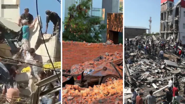
In Venezuela, civil protection agencies were forced to pivot immediately from responding to a standard earthquake to managing the compounding disasters of a seismic doublet. Because the Venezuelan event occurred at a shallow depth of roughly 10 kilometers, emergency response teams faced immediate challenges regarding structural collapses, infrastructure damage, and localized landslides. Search-and-rescue protocols were deployed instantaneously, with government ministries coordinating field hospitals and structural engineering assessments to determine which buildings remained safe for occupancy.
Implications
The 2026 earthquakes in Colombia and Venezuela offer profound lessons for seismology, urban planning, disaster preparedness, and public psychology in South America—a continent intimately familiar with the restless nature of the Pacific Ring of Fire and complex Caribbean-South American plate interactions.
The Physics of Depth vs. Proximity
The stark contrast in hypocentral depth between the two events highlights a fundamental principle of seismology: depth dictates distribution, while proximity dictates localized devastation.
In Colombia, the 103-kilometer depth meant that the seismic energy was distributed over a broader geographic area before reaching the surface. While this caused widespread, synchronized rolling motions that alarmed millions across multiple regions, it structurally mitigated the hyper-localized, ground-ripping destruction often caused by shallow quakes. Conversely, Venezuela’s 10-kilometer depth concentrated the brunt of the 7.5-magnitude energy directly into the upper crust. This proximity meant that buildings, bridges, and roads absorbed the raw, unattenuated shockwaves, leading to a much higher potential for structural distress.
The Hazard of Seismic Doublets
The 39-second gap in the Venezuelan event serves as a chilling reminder of the unpredictability of fault mechanics. Seismic doublets challenge traditional building codes and emergency response frameworks. Most structural engineering standards assume a single primary shock followed by a degrading sequence of aftershocks, allowing structures to absorb one major blow before inspection. When a second, equally powerful (or larger) shock hits less than a minute later—while structures are already resonating, swaying, and suffering from accumulated micro-fractures—the risk of catastrophic progressive collapse multiplies exponentially.
Infrastructure and Resiliency in the 21st Century
As Colombia celebrates (or rather, reevaluates) the fact that its 7.4-magnitude quake is the most powerful of the century thus far, civil authorities are forced to re-examine building codes, retrofitting initiatives, and seismic microzonation maps. Schools, hospitals, and critical infrastructure must be audited to ensure they can withstand not just moderate tremors, but century-scale megathrusts originating from both shallow crustal faults and deep-focus subduction zones.
Public Education and the Myth of Prediction
Both crises underscored a persistent challenge for modern societies: the psychological toll of uncertainty. In the aftermath of the Colombian and Venezuelan events, social media platforms were flooded with rumors, amateur theories, and fraudulent "prediction" models claiming to forecast upcoming aftershocks or secondary quakes.
Official institutions like the SGC have redoubled their educational outreach campaigns. By consistently communicating that earthquakes cannot be predicted, governments are shifting their focus toward preparedness rather than prediction. Cultivating a culture of prevention—through routine evacuation drills, secure architectural standards, and reliable family emergency kits—remains the single most effective defense against the unpredictable fury of the earth.
Ultimately, while the earth beneath Colombia and Venezuela shook for very different mechanical reasons in 2026, the events have permanently altered the seismic risk awareness of both nations, serving as a powerful testament to the dynamic, ever-shifting tectonic forces that shape the South American continent.




Leave a Reply