

Main Facts
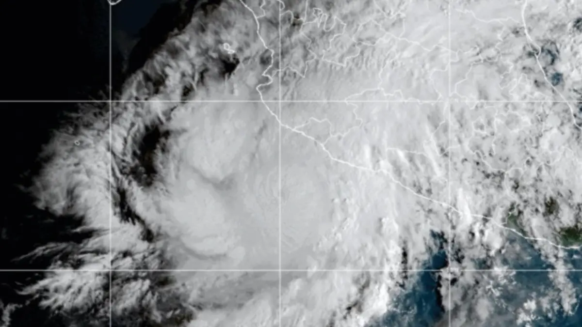
The western coastline of Mexico is on high alert as Hurricane Simón rapidly intensifies into a powerful Category 4 hurricane on the Saffir-Simpson wind scale. According to the latest bulletins issued by the National Water Commission (Comisión Nacional del Agua — Conagua), the eye of the hurricane was recently located approximately 105 kilometers (65 miles) west-northwest of Manzanillo in the State of Colima, and roughly 95 kilometers west of Manzanillo alongside 175 kilometers south-southeast of Cabo Corrientes.
Simón has altered its trajectory, moving dangerously parallel to the country’s western littoral. The storm’s menacing proximity to the shore brings life-threatening hazards, including catastrophic winds, torrential downpours, severe inland flooding, mudslides, and hazardous marine conditions characterized by towering storm surges and exceptionally high waves.
Federal, state, and municipal authorities have mobilized emergency protocols across several states. Mandatory and precautionary evacuations are currently underway in vulnerable coastal settlements, low-lying regions, and flood-prone zones across the states of Jalisco, Colima, Nayarit, and Michoacán. Civil Protection agencies have urged citizens residing in these designated impact zones to immediately seek designated storm shelters or secure indoor locations and remain there until official clearance is given.
Chronology of Events
The rapid evolution of Hurricane Simón has caught the attention of national and international meteorological agencies, unfolding through a tense sequence of atmospheric developments and swift administrative responses:
- Initial Formation and Intensification: Simón originated as a tropical depression off the southwestern coast of Mexico, fueled by unusually warm sea-surface temperatures in the Eastern Pacific basin. Favorable atmospheric conditions, including low wind shear, allowed the system to organize rapidly, transitioning from a tropical storm into a hurricane within a compressed timeframe.
- Rapid Escalation to Major Hurricane Status: Within less than 48 hours, feeding on abundant oceanic heat and moisture, Simón underwent explosive intensification. Sustained wind speeds surged, propelling the system past Category 1, 2, and 3 thresholds until it officially attained Category 4 status—a major hurricane capable of inflicting catastrophic structural damage upon impact.
- Shift in Trajectory and Close Approach: The storm altered its forward movement, wobbling slightly closer to the mainland. Conagua tracking systems pinned the center of the hurricane dangerously close to the Colima and Jalisco coastlines. This shift compressed the window of preparation for coastal communities stretching from Michoacán up to Nayarit.
- Emergency Declarations and Evacuations: As Conagua and the National Meteorological Service (Servicio Meteorológico Nacional — SMN) issued red alerts, federal and local governments activated emergency protocols. Authorities began forced and voluntary evacuations of beachfront communities, fishing villages, and river-adjacent neighborhoods.
- Current Status: Hurricane Simón remains just offshore, maintaining its Category 4 intensity. Continuous radar monitoring tracks its minute-by-minute shifts as meteorologists evaluate the exact timing and location of its impending landfall or closest point of approach to the Mexican western seaboard.
Supporting Data and Meteorological Metrics
Understanding the sheer scale and potential destructiveness of Hurricane Simón requires a close examination of the meteorological data provided by Conagua, the National Hurricane Center (NHC) models, and local civil protection telemetry:
- Current Position: The center of the storm is situated roughly 105 kilometers west-northwest of Manzanillo, Colima, and 175 kilometers south-southeast of Cabo Corrientes.
- Saffir-Simpson Classification: Category 4. This classification indicates sustained winds typically ranging between 209 and 251 km/h (130–156 mph). Structures built of weaker materials can experience complete roof failure and exterior wall collapse, while even well-built residential and commercial buildings may suffer severe structural damage.
- Wind Fields: Hurricane-force winds extend outward several kilometers from the center, with tropical-storm-force winds covering a significantly broader radius, battering coastal infrastructure well before the eye makes its closest pass.
- Rainfall Projections: The system is dragging massive bands of moisture across western Mexico. Cumulative rainfall totals are expected to reach extreme levels, with localized accumulations posing an immediate threat of flash floods and sudden mudslides, particularly in mountainous and ravine-heavy terrains in Colima, Jalisco, and Michoacán.
- Marine Conditions: Coastal waters are experiencing severe disruptions. Wave heights along the shores of Jalisco and Colima have escalated dramatically, generating violent surf, dangerous rip currents, and significant coastal erosion. Ports in the affected zones have been closed to all navigation, halting commercial shipping, fishing, and tourism activities.
Official Responses and Government Directives
The federal government of Mexico, alongside state administrations, has mounted a coordinated, multi-agency response to mitigate the loss of life and property damage associated with Hurricane Simón.
Presidential and Federal Coordination
Federal leadership has taken a direct role in communicating the gravity of the emergency. In a formal public statement disseminated via digital channels, President Claudia Sheinbaum Pardo issued an urgent plea to residents within the danger zone:
"In view of the imminent impact of Category 4 Hurricane Simón, we urge the population in the coastal municipalities of Jalisco, Colima, Nayarit, and Michoacán to remain sheltered until official notice is given that the danger has passed… Precautionary evacuation work toward safe zones continues; our priority is to protect ourselves. We appreciate your cooperation; let us remain attentive to civil protection recommendations and avoid traveling on public thoroughfares."
This directive underscores the government’s zero-tolerance approach toward public complacency. The Mexican Navy (Secretaria de Marina — SEMAR) and the National Guard (Guardia Nacional) have activated Plan Marina and Plan GN-A, respectively. These deployment plans mobilize thousands of active-duty personnel to assist with evacuation logistics, secure perimeter areas against looting, establish emergency soup kitchens, and prepare for immediate search-and-rescue operations post-impact.
Local Civil Protection Measures
State-level Civil Protection units in Colima, Jalisco, Nayarit, and Michoacán have established permanent command centers. Schools in high-risk municipalities have been suspended indefinitely to serve as temporary storm shelters. Emergency supplies, including potable water, non-perishable food items, medical kits, and heavy-duty rescue machinery, have been pre-positioned in strategic zones to ensure rapid deployment once the storm passes.
Furthermore, municipal authorities have heavily restricted access to coastal strips, boardwalks (malecones), and rocky outcrops. Police patrols are actively monitoring beaches to enforce bans on recreational water activities and sightseeing near the turbulent ocean front.
Implications for Infrastructure, Economy, and Daily Life
The arrival of a Category 4 system like Hurricane Simón carries profound socio-economic, infrastructural, and environmental implications for western Mexico.
Infrastructure Vulnerability
The combination of destructive winds and torrential rain threatens critical infrastructure. Power grids in Colima and Jalisco are bracing for widespread failures, as falling trees and flying debris snap utility poles and down high-voltage transmission lines. Extended power outages will not only disrupt residential life but also threaten water treatment plants and cold-chain storage facilities for food and medicine.
Transportation networks are facing severe bottlenecks. Major federal highways connecting coastal ports to inland commercial hubs are susceptible to mudslides, bridge washouts, and debris blockages. Airports within the impact zone, including regional hubs handling tourist and commercial traffic, have implemented strict flight cancellations and schedule modifications. Passengers have been strongly advised to verify flight statuses directly with airlines before attempting transit to any regional air terminals.
Economic Impact and Agriculture
The regional economy, heavily reliant on coastal tourism, commercial fisheries, and agriculture, faces significant setbacks. Hotels, resorts, and local businesses along the Riviera Nayarit, Puerto Vallarta, and Manzanillo corridors have faced mass cancellations, empty rooms, and mandatory closures during what would otherwise be active operational periods.
In the agricultural sector, heavy downpours and sustained winds threaten extensive crop damage. Low-lying banana plantations, cornfields, and horticultural operations in Jalisco and Michoacán risk total inundation, which could trigger temporary spikes in local food prices and lead to long-term economic recovery challenges for smallholder farmers.
Environmental and Public Health Concerns
Beyond immediate physical destruction, major hurricanes pose secondary environmental and health hazards. Stagnant floodwaters resulting from overflowing rivers and overwhelmed urban drainage systems elevate the risk of waterborne diseases, mosquito-breeding vectors, and gastrointestinal infections. Environmental authorities are also monitoring potential industrial runoff and chemical leaks from coastal storage facilities compromised by storm surges.
Long-Term Outlook
As Hurricane Simón continues its menacing crawl near the Mexican coast, the overarching priority remains the preservation of human life. Once the core of the storm completes its passage or makes landfall, emergency assessment teams will deploy immediately to initiate damage mapping, clear blocked arteries, restore essential services, and begin the arduous process of national recovery.
Meteorological authorities reiterate that the situation remains fluid. Citizens across western Mexico are instructed to ignore unverified rumors on social media and rely exclusively on updates broadcast by Conagua, the SMN, and official Civil Protection channels as Hurricane Simón writes its chapter in the region’s meteorological history.




Leave a Reply