

By Environmental & Energy Desk
Published: March 2026
Main Facts
Offshore wind energy development is rapidly transforming the maritime landscape of the United States, particularly along the coast of Rhode Island and southern New England. As massive wind turbines rise on the horizon to harness renewable energy, a complex infrastructure challenge unfolds out of sight: transporting that power back to the mainland via thousands of feet of high-voltage submarine cables.
However, laying these power lines across the Atlantic seabed is not as simple as dropping a line on a flat floor. Millennia ago, retreating glaciers left behind vast, jagged boulder fields that litter the ocean floor. For generations, commercial fishermen have navigated these treacherous terrains, meticulously charting underwater hazards to protect their expensive trawl nets, vessels, and crews.
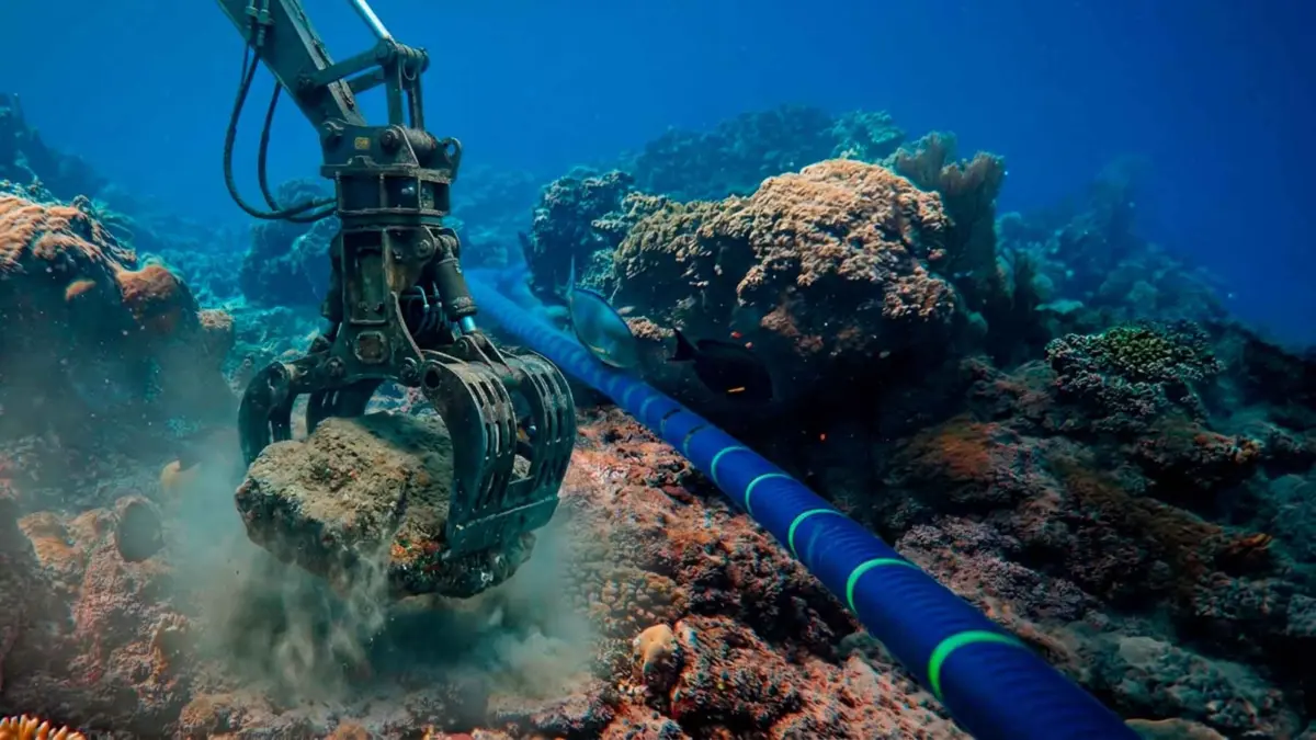
Now, major energy developers are moving these ancient boulders—some weighing several tons and measuring over a foot and a half in diameter—using heavy hydraulic machinery to clear designated cable pathways. While this engineering feat solves the immediate problem for the energy sector, it introduces a cascade of unintended consequences. Relocating a boulder that has rested in the exact same spot for thousands of years alters the centuries-old mental maps of commercial fishermen, threatens vital benthic ecosystems, and creates new, unexpected snag hazards across previously safe fishing grounds.
Chronology
To understand the current friction between offshore energy expansion and traditional fisheries, it is essential to trace how the geography of the seabed has governed human activity in New England over time:
- Post-Glacial Epoch (Thousands of Years Ago): The retreat of the Laurentide Ice Sheet deposits vast moraines, erratic boulder fields, and complex rocky outcrops across the continental shelf of southern New England and Rhode Island, creating a rugged and diverse underwater topography.
- Pre-Industrial to Modern Era: Generations of commercial fishermen slowly decode the mysteries of the seabed. Through trial, error, and oral histories, they build intricate, generational mental maps of where trawl nets will snag and where they can safely sweep for fish and invertebrates.
- The 2020s (The Offshore Wind Boom): Federal and state climate mandates accelerate the approval and construction of commercial-scale offshore wind farms along the U.S. East Coast. Developers begin drafting blueprints for massive array fields and export cable corridors traversing traditional fishing grounds.
- Recent Years: As pre-construction surveys reveal thousands of seabed boulders blocking proposed cable routes, energy companies seek permits from state and federal regulators to lift and relocate these obstacles using specialized subsea equipment.
- Present Day (2025–2026): Legal and environmental research—highlighted by recent publications from the Marine Affairs Institute at Roger Williams University School of Law and Rhode Island Sea Grant—brings the issue to the forefront. Experts, policymakers, and industry stakeholders begin calling for cross-industry collaboration to balance renewable energy mandates with the preservation of marine ecosystems and fishing heritage.
Supporting Data and Legal Frameworks
The scale of the issue is thoroughly detailed in recent academic and legal literature, most notably in the 2025 study by D. Shea titled Boulder relocation for offshore energy development in Rhode Island: Artificial reefs and cross-industry collaboration, published through the Marine Affairs Institute at Roger Williams University School of Law and the Rhode Island Sea Grant Legal Program.
According to the report, the physical removal of boulders involves heavy marine machinery equipped with robotic claws or lifting cradles capable of hoisting massive stones off the ocean floor. The data highlights several key considerations:
- Scale of Relocation: Hundreds of individual boulders, many exceeding 1.5 feet in diameter, must be moved to create clear trenches for burial or surface-laying of inter-array and export cables.
- Regulatory Oversight: Boulder displacement cannot occur arbitrarily. Every relocation project requires rigorous environmental review, state permits, and federal authorizations to ensure compliance with marine protection laws.
- Benthic Habitat Impact: The area surrounding these glacial erratic rocks constitutes vital benthic habitat. These micro-ecosystems support diverse communities of demersal fish, crustaceans, and sessile invertebrates. Moving a rock disrupts not just the stone itself, but the biological community that has adapted to its shelter.
- Artificial Reef Potential: Rather than scattering displaced rocks randomly across the ocean floor—which exponentially increases the risk of unpredictable commercial fishing gear snags—scientists and legal experts are exploring whether consolidated boulder groupings could be intentionally designed to function as beneficial artificial reefs.
Official Responses and Stakeholder Perspectives
The intersection of green energy infrastructure and traditional maritime commerce has sparked intense dialogue among government regulators, energy developers, and fishing associations.
The Energy Sector Perspective
Renewable energy developers emphasize that burying and protecting export cables is critical to the operational reliability of offshore wind farms. Without clearing the path of massive glacial erratic boulders, submarine cables risk being bridged, suspended, or abraded by dynamic ocean currents acting upon the rocks. Developers argue that boulder relocation is a standard, highly regulated engineering practice designed to minimize environmental disruption while ensuring the transmission of clean electricity to millions of homes.
The Commercial Fishing Industry Perspective
Commercial fishermen, however, view the uncoordinated shifting of seabed geography as an existential threat to their livelihoods. For centuries, the seafloor has been their workplace. When a multi-ton boulder is quietly moved from a charted hazard zone to an uncharted stretch of flat bottom, it transforms a "safe" towing lane into a sudden gear-destroying trap.
A single net snag can cost tens of thousands of dollars in damaged or lost gear, not to mention the severe safety hazards posed to vessel stability if a winch suddenly locks or a cable parts under tension. Fishermen argue that while they support a diverse energy economy, their ancestral knowledge of the sea is being sidelined by rushed industrial planning.
Legal and Academic Insights
Legal scholars and marine resource managers point out that mitigating these conflicts requires early, institutionalized cross-industry communication. By involving fishermen in the earliest phases of spatial planning, regulators can map out historical fishing lanes and high-risk snag areas before a single blade of a crane touches the water.
Implications
The clash over moving glacial boulders for offshore wind cables carries profound ecological, economic, and cultural implications for the Northeast and the broader global energy transition.
1. Ecological and Habitat Fragmentation
The relocation of seabed rocks forces a re-evaluation of how we measure environmental impact. While clean energy is vital for combating global climate change, localized marine construction can fragment delicate benthic habitats. While turning displaced boulders into structured artificial reefs offers a promising mitigation strategy—potentially concentrating fish populations and enhancing biodiversity—it requires precise geographical planning. If done poorly, it simply relocates ecological disruption from one zone to another.
2. The Erosion of Generational Knowledge
Perhaps the most intangible yet significant casualty of uncoordinated seabed modification is the erosion of maritime tradition. For generations, commercial fishing families have maintained an oral and practical cartography of the Atlantic floor. Their maps are etched into memory and passed down through captains and crewmates. Altering the physical reality of the seabed devalues this hard-earned knowledge, introducing a new era of uncertainty where seasoned mariners can no longer fully trust their historic charts.
3. A Blueprint for Cross-Industry Collaboration
Ultimately, the Rhode Island case study serves as a critical test case for coexistence between two vital maritime industries: commercial fisheries and offshore renewable energy. Experts agree that the path forward lies in radical transparency and co-planning.
By integrating the experiential data of fishermen with the high-tech mapping tools of marine engineers, stakeholders can establish a standardized registry of boulder movements. This ensures that every stone lifted to make way for a green energy cable is cataloged, its new home accounted for, and its impact on both marine life and commercial fishing minimized.
As the global push for offshore wind accelerates, the lessons learned in the boulder fields of Rhode Island will resonate worldwide, proving that the transition to a sustainable future must respect both the health of marine ecosystems and the human traditions rooted within them.



Leave a Reply