

By Global Environmental Desk
Published: September 2026
Main Facts
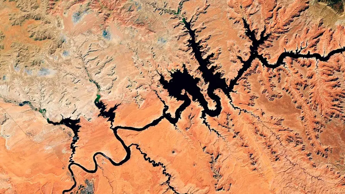
Satellite imagery provided by NASA tells a stark, unmistakable story of transformation across the American Southwest. Where deep blue waters once reflected the canyon walls for miles, vast stretches of bleached, cracked earth and exposed sediment now dominate the landscape of Lake Powell.
By September 2026, the second-largest reservoir in the United States plummeted to its lowest level in recorded history, shattering a previous low-water record set just three years prior in 2023. Dropping to a concerning elevation of 3,517.24 feet above sea level, the country’s vital hydrological lifeline—upon which more than 40 million people and five million acres of agricultural land depend—has crossed a critical tipping point much faster than climate scientists and water resource managers had anticipated.
The crisis at Lake Powell is not an isolated weather anomaly; it is the sharpest symptom yet of a multi-decade megadrought choking the Colorado River Basin. Driven by an unprecedented "snow drought" in the Rocky Mountains, extreme heatwaves, and compounding structural deficits, the crisis has forced federal, state, and tribal authorities to implement emergency measures to stave off total hydrological collapse.
Chronology of a Crisis: The Timeline to 2026
To understand how Lake Powell reached this critical juncture, experts trace a timeline marked by dwindling snowpacks, emergency interventions, and accelerating climate pressures.
- September 2017: Following a series of wet winters, Lake Powell enjoyed one of its highest water elevations of the decade. The area immediately above the Glen Canyon Dam was fully submerged, resembling a stable, deep reservoir.
- April 13, 2023: Prior records were shattered as the lake fell to 3,519.92 feet above sea level, prompting fierce debates among stakeholders in the seven states that share the Colorado River Basin over mandatory water cuts.
- April 2026: Recognizing that the lake was on a trajectory to breach the critical minimum threshold required to generate hydroelectric power before the end of summer, the U.S. Bureau of Reclamation (USBR) initiated rapid emergency interventions. Deliveries from the Flaming Gorge Reservoir in Utah and Wyoming were greenlit, and environmental water releases were abruptly canceled.
- August 2026: Lake Mead—the downstream neighbor to Lake Powell—also plunged to historic lows, reflecting the systemic exhaustion of the entire Colorado River network.
- September 10, 2026: Lake Powell officially hit its absolute lowest historical mark at 3,517.24 feet. NASA’s Landsat 8 satellite captured images of vast, fragmented channels of dry sediment where deep water had stood less than a decade prior, confirming that Powell had broken its own historic low-water record in less than four years.
Supporting Data and Meteorological Drivers
The primary culprit behind the dramatic 2026 drop is what hydrologists refer to as a "snow drought." During the winter of 2025–2026, the high-elevation mountain ranges that feed the Colorado River recorded an uncommonly sparse accumulation of winter snowpack.
The Colorado River relies heavily not on direct rainfall, but on the steady, seasonal snowmelt that occurs between March and June. When winter snowfall fails to materialize, this crucial hydrological pulse vanishes. Compounding the issue, relentless summer heatwaves triggered severe evaporation rates. Much of the melting snow was lost to the dry desert air before ever reaching the tributaries feeding the major reservoirs.
This hydrological stress sits atop a persistent megadrought that has gripped the American Southwest since the turn of the 21st century. According to data from NASA’s Western Land Data Assimilation System (WLDAS), soil moisture across the basin remains at or near record lows, creating a "thirsty soil" phenomenon that absorbs precious runoff before it can replenish the state’s storage infrastructure.
Official Responses and Emergency Interventions
Faced with the imminent threat of reaching "dead pool"—the point at which water is too low to pass through the dam’s turbines or outlet works—federal and regional agencies executed drastic mitigation strategies throughout 2026.

1. Upstream Transfers and Downstream Restrictions
The USBR ordered emergency water transfers from the Flaming Gorge Reservoir located in northern Utah and southern Wyoming. Simultaneously, water releases from Lake Powell down to Lake Mead were severely restricted, creating a delicate balancing act to preserve volume in both reservoirs without completely starving downstream users.
2. Cancellation of Environmental Releases
To save every possible inch of water, federal managers took the controversial step of canceling two key ecological operations:
- The Spring "High-Flow Experiment": A controlled flood designed to move sediment and rebuild sandbars along the Grand Canyon, creating crucial habitats for native fish species.
- The Late Summer "Cool Flow": A targeted release meant to moderate water temperatures for endangered native aquatic life.
While these cancellations drew sharp criticism from conservation groups, water managers insisted that preserving the structural and operational integrity of the Glen Canyon Dam—the vital anchor of the region’s hydroelectric grid—was paramount.
Implications for the American Southwest
The implications of Lake Powell’s decline stretch far beyond recreational boating or scenic canyons. They represent a fundamental threat to the economic, urban, and agricultural stability of the American Southwest.
Urban Centers on Edge
More than 40 million citizens across major metropolitan hubs—including Las Vegas, Phoenix, Los Angeles, and San Diego—rely directly or indirectly on the Colorado River system for municipal water supplies and drinking water. While these cities have invested heavily in conservation, water recycling, and desalination, the ongoing decline of Powell and Mead places immense pressure on municipal infrastructure.
Agricultural Vulnerability
Agriculture is the largest consumer of water in the Colorado River Basin, feeding over five million acres of productive farmland. Crops ranging from alfalfa and hay to winter vegetables and fruit orchards are heavily dependent on predictable irrigation allocations. As water deliveries face unprecedented cuts, farming communities are forced into difficult fallowing programs, threatening regional food security and rural economies.
The Threat to Renewable Energy
The Glen Canyon Dam is one of the most critical hydroelectric power plants in the western United States. A drop in water levels directly compromises its capacity to generate electricity, threatening power grids across multiple states and forcing utilities to seek alternative, often more expensive and carbon-intensive, energy sources.
Technology and Satellite Monitoring to the Rescue
While engineers manage the crisis on the ground, a sophisticated network of space-borne instruments and data platforms—many funded by NASA—is providing the foresight needed to navigate the crisis.
- WLDAS (Western Land Data Assimilation System): Delivers real-time data on soil moisture, snow-water equivalent, and evapotranspiration, feeding directly into the U.S. Drought Monitor.
- Drought Severity Assessment Tool: Developed in partnership with the Navajo Nation, this tool tracks localized drought indicators, precipitation trends, and vegetation health across tribal lands, expanding its coverage in 2025 to include the Chickasaw and Choctaw Nations of Oklahoma.
- Integrated Colorado River Assessment Tool: Created by Arizona State University and the Central Arizona Project, this platform consolidates satellite data regarding snowpack, surface water, groundwater, and soil moisture into a single interactive dashboard for basin-wide decision-making.
Looking Ahead
The future of the American Southwest hinges on the winter weather patterns of 2026–2027. If the upcoming winter brings another meager snowpack to the Rocky Mountains, the advanced warning systems deployed by scientists will sound the alarm even earlier. With reservoirs sitting at historical minimums, the margin for error has vanished. The unfolding crisis at Lake Powell serves as a stark reminder that the region’s water management paradigms must permanently adapt to a hotter, drier reality.




Leave a Reply