

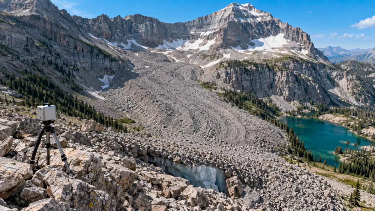
SALT LAKE CITY, UTAH — To the thousands of hikers who traverse its rugged trails each season, Mount Timpanogos is a familiar icon of the Wasatch Range, towering majestically over the bustling metropolitan areas of Salt Lake City and Provo. Near Emerald Lake, climbers cross what appears at first glance to be a mundane, albeit expansive, landscape of loose rock, scree, and alpine debris.
Yet, beneath the boots of unsuspecting adventurers lies a massive, frozen secret. Thousands of tons of ancient ice are locked away under this cloak of stone—a geological formation known as a rock glacier. For decades, the true scale, volume, and internal composition of these hidden reservoirs remained entirely speculative, largely because drilling through meters of shifting debris is both impractical and environmentally disruptive.
That barrier was recently broken. In a groundbreaking study published in the Journal of Geophysical Research: Earth Surface, an interdisciplinary team of researchers successfully peered inside the mountain’s frozen heart. By measuring invisible shifts in gravity and deploying advanced three-dimensional computer modeling, scientists have unveiled a staggering subterranean world of ice, rewriting our understanding of alpine hydrology and climate resilience in the American West.
Main Facts: The Discovery Beneath the Scree
At the center of this scientific breakthrough is the Timpanogos Rock Glacier. While traditional glaciers are visible, gleaming rivers of ice exposed to the open air, rock glaciers are disguised. They consist of massive bodies of ice buried beneath a thick insulating blanket of rock debris. This rocky armor protects the internal ice from solar radiation and warm ambient air, allowing the formation to persist in environments where traditional glaciers would quickly melt away.
Utah alone is home to an estimated 836 rock glaciers. However, until recently, researchers had virtually no precise data regarding how much water these formations actually stored.
Using a high-precision gravimeter—an instrument sensitive enough to detect minute fluctuations in Earth’s gravitational pull—researchers mapped the interior of the Timpanogos Rock Glacier during the autumn of 2024. Because ice is significantly less dense than solid rock and surrounding geological strata, localized variations in surface gravity provided a reliable diagnostic signature of what lay beneath.
The results were astonishing. The Timpanogos Rock Glacier contains an estimated 55 million cubic feet of ice—a volume roughly equivalent to 600 Olympic-sized swimming pools. Furthermore, the researchers discovered that the core of the rock glacier is remarkably pure, consisting of approximately 83% ice and only 17% loose rock in its deepest sections, with an average thickness of about 62 feet and deeper central pockets reaching up to 150 feet.
Chronology: A Season of Invisible Discovery
The journey to mapping Mount Timpanogos’s hidden interior unfolded over several months of meticulous fieldwork and advanced data processing.
- Late Summer 2024: Preparations begin for a non-invasive geophysical survey of the Mount Timpanogos area. Recognizing the limitations of core drilling—which damages fragile alpine ecosystems and offers only localized data—the research team, led by scientist Bronson Cvijanovich, opts for gravimetry.
- Autumn 2024: Cvijanovich and his colleagues execute six grueling field expeditions up the slopes of Mount Timpanogos. Operating in the crisp, unpredictable weather of the Utah autumn, the team records 232 precise gravity measurements, spacing each station roughly 80 feet apart across the rough terrain of the rock glacier.
- Late 2024 to 2025: Back in the laboratory, the raw gravitational data undergoes extensive correction. The team must mathematically filter out environmental "noise"—gravitational fluctuations caused by variations in elevation, latitude, Earth tides, and the relative positions of the Sun and the Moon.
- Analytical Phase: Using a sophisticated 3D Bayesian inversion model, the researchers translate the corrected gravitational data into a high-resolution, three-dimensional representation of the glacier’s internal architecture.
- Early 2026: The findings are cross-referenced with geophysical data from ten other rock glaciers to establish a global scaling relationship between surface dimensions and internal ice volume.
- Mid-2026: The official study is published in the Journal of Geophysical Research: Earth Surface, detailing not only the Timpanogos metrics but also scaling up regional and global estimates for rock glacier ice storage.
Supporting Data: Crunching the Numbers on Hidden Water
The numbers emerging from the Timpanogos study provide a stark quantitative realization of how much water is locked away in alpine environments across the globe.
- 232: The total number of gravity measurement stations established across the Timpanogos Rock Glacier during the fall of 2024 field campaign.
- 55 Million Cubic Feet: The estimated volume of ice harbored within the Timpanogos Rock Glacier alone.
- 62 to 150 Feet: The average thickness of the rock glacier, with deeper central cores plunging down to 150 feet below the surface debris.
- 83%: The ice purity concentration found within the core of the formation, proving that these are not merely piles of damp rocks, but genuine, dense ice bodies wrapped in stone.
- 836: The total count of verified rock glaciers identified within the state of Utah alone.
- 815,000 Acre-Feet: The estimated cumulative water equivalent stored within Utah’s collective rock glacier inventory, extrapolated from the study’s scaling models.
- 48 Gigatonnes: The staggering global estimate for water storage housed within rock glaciers worldwide.
Official Responses and Scientific Perspectives
The implications of the study have drawn widespread praise from the glaciology and hydrology communities, who have long struggled to quantify subterranean cryospheric resources.
Dr. Bronson Cvijanovich, lead author of the study, emphasized the conceptual shift required to understand these alpine features. "When people look at these mountains from the trails, they see a barren, uninteresting field of rocks," Cvijanovich noted. "What our gravimetry work shows is that nature has hidden vast, pristine reservoirs of ice right beneath our feet, protected by the very stones that cover them."
Co-researchers, including M. S. Thorne, S. Pachhai, L. S. Anderson, I. Tochimani-Hernandez, C. L. Hardwick, and T. van Dam, stressed the elegance and utility of the 3D Bayesian inversion technique. By leaning on non-invasive physics, scientists can now assess sensitive alpine ecosystems without driving heavy machinery or boring destructive holes into protected mountain ranges.
Environmental geographers point out that while these formations have historically been overlooked in traditional water resource management plans, their sheer volume demands a policy re-evaluation. Although not all the water locked within these stones is easily accessible for direct human consumption, these subterranean glaciers act as critical hydrological regulators, slowly releasing meltwater into lower-altitude streams during the height of dry summer months.
Implications: Climate Change, Water Security, and the Future
As global temperatures continue to rise, traditional glaciers around the world are retreating at unprecedented rates, frequently capturing headlines and sparking ecological anxiety. However, rock glaciers present a complex and often overlooked chapter in the story of climate change.
Because they are insulated by thick layers of rock debris, rock glaciers are remarkably resilient to short-term atmospheric warming. While a traditional glacier will rapidly melt when exposed to successive heatwaves, a rock glacier responds with a significant lag time. The outer stone layer acts as a thermal buffer, delaying the thermal degradation of the ice core.
Nevertheless, they are not immune. As atmospheric temperatures climb over multi-decadal timescales, even these insulated ice masses are beginning to experience internal warming and accelerated melting.
The implications for regional water security are profound. In semi-arid regions like the American Intermountain West, seasonal snowpack and glacial runoff are the lifeblood of agricultural industries, municipal water supplies, and delicate river ecosystems. Knowing that Utah’s rock glaciers contain an estimated 815,000 acre-feet of water equivalent fundamentally changes hydrological models. Water resource managers must now incorporate these hidden subterranean ice reserves into long-term drought planning and climate adaptation strategies.
Furthermore, the methodology pioneered on Mount Timpanogos opens the door to global applications. With a reliable, non-invasive technique to measure internal ice volumes via gravity anomalies, researchers can now scale up investigations to assess thousands of similar formations across the Rocky Mountains, the Andes, the Alps, and high-Asia.
Ultimately, the research on Mount Timpanogos serves as a humbling reminder of the hidden complexities of our natural world. Beneath the ordinary grey stones of a popular hiking trail lies a monumental archive of frozen water—a silent, resilient frozen asset that may well hold the key to sustaining alpine ecosystems in a warming future.


Leave a Reply