

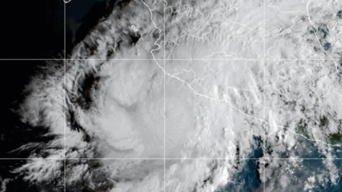
MEXICO CITY — Federal and state authorities across western Mexico are on high alert as Hurricane Simón rapidly intensified into a powerful Category 4 storm on the Saffir-Simpson scale. Threatening multiple coastal states with destructive winds, torrential rainfall, and life-threatening storm surges, the hurricane has prompted emergency evacuations, widespread shelter-in-place orders, and the mobilization of civil protection units.
The Comisión Nacional del Agua (Conagua), alongside the National Meteorological Service (SMN), is tracking the system closely as it moves parallel to the country’s western shoreline. With its core packing extreme wind speeds and expansive cloud bands, the cyclone poses a severe multi-hazard threat to coastal and inland communities alike in the states of Colima, Jalisco, Nayarit, and Michoacán.
Main Facts
Hurricane Simón represents a significant meteorological threat to the Mexican Pacific seaboard due to a combination of rapid intensification, favorable warm ocean waters, and a precarious projected trajectory.
- Current Intensity: Category 4 on the Saffir-Simpson hurricane wind scale, characterized by sustained winds capable of causing catastrophic structural damage, uprooting trees, and causing prolonged power outages.
- Geographic Position: The center of the hurricane was recently located approximately 105 kilometers (65 miles) west-northwest of Manzanillo in the state of Colima, and roughly 95 kilometers west of Manzanillo according to specialized advisory updates, placing it perilously close to the mainland. It is also positioned about 175 kilometers south-southeast of Cabo Corrientes.
- Affected Jurisdictions: Primary alerts and mandatory precautionary measures are concentrated along the coastal and interior municipalities of Colima, Jalisco, Nayarit, and Michoacán.
- Primary Hazards: The primary dangers associated with Hurricane Simón include torrential downpours leading to flash flooding and mudslides in mountainous terrain, destructive hurricane-force winds, and dangerously high storm surges that threaten coastal infrastructure, fishing vessels, and beachside communities.
- Government Response: Federal, state, and municipal civil protection agencies have deployed emergency personnel, initiated preemptive evacuations of vulnerable low-lying and coastal zones, and established temporary emergency shelters for displaced residents.
Chronology of Events and System Evolution
The formation and sudden escalation of Hurricane Simón caught the attention of meteorologists early in October, transitioning from a routine tropical depression into a formidable major hurricane in a compressed timeframe.
Initial Formation and Deep-Water Strengthening
The meteorological disturbance that would eventually become Simón formed several days ago off the southwestern coast of Mexico. Benefiting from exceptionally warm sea surface temperatures—a primary fuel source for tropical cyclones—and low vertical wind shear, the system steadily organized its convection bands. Forecasters at Conagua noted rapid cyclogenesis as the storm absorbed moisture from the Intertropical Convergence Zone (ITCZ).
Transition to Hurricane Status and Shift in Trajectory
As the system tracked northwestward parallel to the Mexican coastline, it officially attained hurricane status. However, a critical change in steering currents caused the storm to wobble and alter its forward speed and trajectory slightly toward the northeast. This shift brought the core dangerously close to the coastlines of Colima and Jalisco. By October 11, 2026, the storm had achieved Category 4 intensity, boasting an exceptionally well-defined eye and a tightly wound core of intense convection.
Close Proximity to Manzanillo
Radar and satellite imagery confirmed that the center of the hurricane positioned itself just 105 kilometers west-northwest of Manzanillo, Colima. This proximity intensified maritime conditions immediately, battering the ports and surrounding coastal ecosystems with towering waves and gale-force outer bands. As the system continues its march, emergency services have transitioned from monitoring phases to active disaster-response operations.
Supporting Data and Meteorological Metrics
Understanding the sheer scale and potential impact of Hurricane Simón requires analyzing the hard data provided by Conagua, the National Hurricane Center (NHC) models, and maritime tracking networks.
The Saffir-Simpson Scale Context
Reaching Category 4 indicates that Simón generates sustained winds between 209 and 251 km/h (130 to 156 mph). At this level:
- Well-built framed homes can suffer severe damage with loss of much of the roof structure and some exterior walls.
- Most trees will be snapped or uprooted, blocking numerous roads and isolating communities.
- Power outages will likely last for weeks, if not months, in the hardest-hit areas, effectively crippling water purification plants, cellular networks, and municipal infrastructure.
Oceanographic and Atmospheric Conditions
- Sea Surface Temperatures (SSTs): Waters in the eastern Pacific along the path of the storm have hovered between 29°C and 31°C (84°F to 88°F), providing ample thermodynamic energy to sustain Category 4 intensity.
- Rainfall Projections: Meteorological models indicate that cumulative rainfall totals could exceed 250 to 350 millimeters (10 to 14 inches) in isolated mountainous regions of Colima, Jalisco, and Michoacán. These volumes dramatically elevate the risk of life-threatening flash floods and catastrophic mudslides, particularly in saturated soils from previous seasonal precipitation.
- Marine Impact: High-resolution wave models predict open-ocean swells exceeding 6 to 8 meters (20 to 26 feet) along the immediate impact zone, creating severe hazardous surf, coastal erosion, and potential overtopping of sea walls and malecones.
Official Responses and Government Directives
As the severity of Hurricane Simón became clear, the highest levels of the Mexican government mobilized to enact preventative protocols and direct public safety communications.
Federal Mobilization and Presidential Directives
Federal authorities, led by national leadership, have stepped in to coordinate inter-state emergency responses. In a widely disseminated public safety directive issued via official communication channels, national leaders directly addressed the populace in high-risk zones:
"Facing the imminent impact of Category 4 Hurricane Simón, we urge the population in the coastal municipalities of Jalisco, Colima, Nayarit, and Michoacán to remain sheltered until official notice is given that the danger has passed," stated federal representatives. "Precautionary evacuation work toward safe zones is ongoing; our priority is to protect ourselves. We appreciate your cooperation; let us continue to pay close attention to civil protection recommendations and avoid traveling on public roads."
Civil Protection and Local Agency Actions
State-level Civil Protection (Protección Civil) offices in Colima, Jalisco, Nayarit, and Michoacán have activated red-alert protocols. Key actions include:
- Evacuations: Mandatory and voluntary evacuations are actively underway for families residing in flood-prone zones, riverbanks, and fragile coastal housing structures.
- Shelter Openings: Dozens of temporary emergency shelters have been opened, equipped with basic medical supplies, potable water, and non-perishable food provisions.
- Port Closures: The Port of Manzanillo and other smaller regional ports have restricted or entirely halted maritime and shipping operations, securing cargo cranes and commercial vessels to prevent harbor accidents.
- Educational and Commercial Suspensions: Local governments suspended non-essential economic activities, public transportation services, and in-person classes to keep citizens off the roads and out of harm’s way.
Implications for Infrastructure, Economy, and Daily Life
The socio-economic and logistical implications of a Category 4 hurricane striking a heavily populated and economically vital stretch of Mexico’s Pacific coast are profound.
Infrastructure and Transportation Disruption
The combination of violent winds and torrential rains poses an immediate threat to regional infrastructure:
- Aviation: Major and regional airports within the projected path—including those serving coastal tourist corridors—have experienced cancellations, delays, and preventative closures. Passengers have been strongly advised to verify flight statuses directly with airlines before attempting transit to terminal buildings.
- Roadways: Landslides, rockfalls, and fallen power lines are expected to sever key federal and local highway connections, temporarily cutting off remote coastal settlements from urban emergency hubs.
- Utilities: Electrical grids will face catastrophic stress. Power distribution companies have staged repair crews and heavy equipment just outside the anticipated impact zone to deploy the moment winds subside to safe operational thresholds.
Economic and Agricultural Sectors
The agricultural sectors in Colima and Jalisco—known for vital crop production, livestock, and tropical fruit cultivation—face severe economic vulnerability. High-velocity winds can decimate banana, papaya, and mango plantations, while standing water can rot root crops and submerge pastures. Furthermore, temporary halts in tourism along popular beach destinations will impact regional hospitality revenues during what is typically a crucial shoulder season.
Public Health and Long-Term Recovery
Beyond immediate rescue operations, health authorities are preparing for secondary threats that traditionally follow major tropical systems:
- Waterborne Diseases: Contaminated municipal water supplies and standing floodwaters create environments ripe for gastrointestinal illnesses and mosquito-borne vectors such as dengue, Zika, and chikungunya.
- Psychological Impact: Displaced families facing the destruction of homes and livelihoods will require sustained psychological support and long-term housing assistance coordinated by federal and municipal welfare programs.
Outlook and Recommendations for Citizens
As Hurricane Simón continues to evolve, meteorological agencies emphasize that the margin for error is narrow. Even minor wobbles in the storm’s track could drastically alter which specific municipalities bear the brunt of the eyewall’s destructive fury.
Key Safety Instructions for Residents
Civil protection authorities continue to issue strict safety guidelines for all individuals residing in or near the affected zones:
- Strict Confinement: Remain indoors in a secure, windowless interior room on the lowest safe floor if living in a solid structure. Evacuate immediately if instructed by local authorities to move to a designated public shelter.
- Secure Loose Objects: Tie down or bring indoors any outdoor furniture, potted plants, tin roofs, and construction materials that could become airborne projectiles in Category 4 wind conditions.
- Emergency Supplies: Ensure emergency kits are fully stocked with at least 72 hours of potable water, non-perishable food, flashlights, extra batteries, a battery-powered radio, first-aid supplies, and essential personal medications.
- Avoid Hazard Zones: Strictly stay away from beaches, coastal promenades (malecones), riverbanks, and drainage canals. Swift-moving flash floods and abnormal marine surges can sweep away individuals and vehicles with terrifying speed.
- Monitor Official Channels: Disregard unverified rumors on social media. Rely exclusively on real-time meteorological updates provided by Conagua, the National Meteorological Service, and local Civil Protection bulletins.
Federal, state, and municipal emergency response teams remain on maximum alert, monitoring every atmospheric shift as Hurricane Simón tests the resilience of Mexico’s western coast.



Leave a Reply