

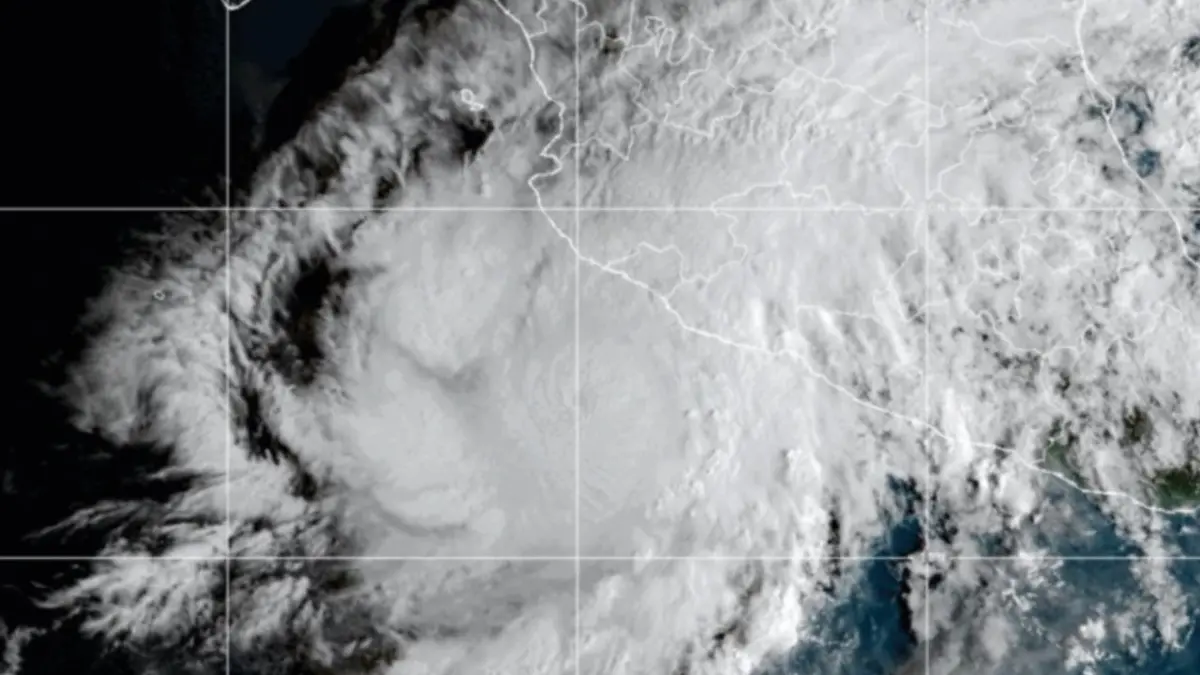
MEXICO CITY — In a sudden and alarming escalation, Hurricane Simón has rapidly transformed into a powerful Category 4 hurricane on the Saffir-Simpson scale, prompting widespread emergency mobilizations and mandatory precautions across Mexico’s western coastline. Federal and state authorities are maintaining round-the-clock vigilance as the formidable weather system tracks perilously close to the mainland, threatening densely populated coastal regions with destructive winds, torrential rainfall, and life-threatening storm surges.
The Comisión Nacional del Agua (Conagua), alongside civil protection agencies, has intensified monitoring efforts as Simón continues to churn off the coast of Colima and Jalisco. With the storm’s core positioned dangerously close to major ports and tourist hubs, federal leadership has stepped in to coordinate urgent evacuations and issue strict stay-at-home mandates for residents in the direct path of the hurricane.
Main Facts
Hurricane Simón represents a severe meteorological threat to western Mexico, characterized by rapid intensification and an unpredictable shift in trajectory.
- Current Intensity: Hurricane Simón has reached Category 4 status on the Saffir-Simpson hurricane wind scale, indicating extremely dangerous sustained winds capable of inflicting catastrophic structural damage, uprooting trees, and causing prolonged power outages.
- Current Location: The center of the hurricane was recently located approximately 105 kilometers (65 miles) west-northwest of Manzanillo, Colima, and roughly 95 kilometers west of Manzanillo according to updated federal tracking, putting it virtually on the doorstep of the coastline. It is also positioned about 175 kilometers south-southeast of Cabo Corrientes.
- Affected States: The states facing the highest immediate risk include Colima, Jalisco, Nayarit, and Michoacán. Coastal municipalities within these regions are experiencing the preliminary bands of the storm, marked by severe gales and deteriorating maritime conditions.
- Primary Hazards: The storm brings compounding threats, including torrential downpours leading to flash floods and mudslides in mountainous terrains, hazardous marine conditions with exceptionally high waves, and destructive wind gusts along coastal strips.
- Emergency Actions: Evacuations are actively underway in low-risk and vulnerable coastal zones. Authorities have strongly urged the public to stay indoors, avoid non-essential travel, and monitor official meteorological channels for real-time updates.
Chronology of Events
The rapid evolution of Hurricane Simón caught many by surprise, transitioning from a standard tropical system into a major hurricane within a compressed timeframe.
Initial Formation and Coastal Approach
In the days leading up to the crisis, meteorological models detected a low-pressure system off the western coast of Mexico. Initially monitored for its potential to bring seasonal rainfall, the system quickly organized over the warm waters of the Pacific Ocean. As environmental conditions—including high sea surface temperatures and low vertical wind shear—proved highly conducive to rapid intensification, the storm gained structured rotation and organized convection.
Shift in Trajectory and Intensification to Category 4
As the system tracked parallel to the Mexican coastline, it executed a subtle shift in trajectory, moving its core closer to the mainland. Within hours, data reconnaissance and satellite imagery confirmed that the system had achieved Category 4 status. Its winds intensified dramatically, turning it into a major hurricane capable of severe regional devastation. The center of the storm locked in at approximately 105 kilometers west-northwest of Manzanillo, Colima, establishing an immediate proximity threat to the shore.
Emergency Mobilization and Evacuation Phase
Recognizing the imminent danger of a Category 4 landfall or close brush, federal and state agencies triggered high-level emergency protocols. Evacuation teams were deployed to low-lying coastal communities, flood-prone areas, and regions susceptible to storm surges. Concurrently, public warnings were escalated through emergency broadcast systems and social media channels, instructing residents in Jalisco, Colima, Nayarit, and Michoacán to seek secure shelter immediately.
Supporting Data and Meteorological Metrics
Meteorological agencies rely on precise scientific frameworks to assess and communicate the severity of tropical cyclones. The metrics surrounding Hurricane Simón underscore the gravity of the situation.
The Saffir-Simpson Hurricane Wind Scale: Category 4
Simón’s classification as a Category 4 hurricane places it just one step below the maximum rating on the Saffir-Simpson scale.
- Sustained Winds: Category 4 hurricanes typically sustain winds between 209 and 251 km/h (130–156 mph). At this velocity, well-built framed homes can sustain severe damage with loss of roof structure and some exterior walls. Lower-floor structures are often completely compromised by structural failure or flying debris.
- Structural Impacts: Power poles and transmission lines are routinely snapped, resulting in total electrical failures that can last for weeks or months. Water treatment plants and local infrastructure face catastrophic disruption.
- Vegetation Damage: Trees are routinely uprooted or snapped entirely, blocking roadways and compounding rescue and relief efforts.
Geographic Coordinates and Proximity Analysis
Conagua’s tracking data places the center of the hurricane at critical distances from key landmarks:
- Distance from Manzanillo, Colima: 105 km west-northwest (and 95 km west in subsequent advisories). Manzanillo houses one of Mexico’s most vital commercial ports, making marine and onshore asset protection a top economic priority.
- Distance from Cabo Corrientes: 175 km south-southeast, placing the northern trajectory vector directly in line to affect coastal Jalisco and neighboring Nayarit.
Marine and Hydrological Indicators
Oceanographic data indicates that wave heights along the coasts of Jalisco and Colima have risen dramatically, generating dangerous surf, rip currents, and coastal erosion. Furthermore, cumulative rainfall projections warn of precipitation totals that could easily trigger severe inland flooding and destructive landslides across the Sierra Madre Occidental foothills.
Official Responses and Government Coordination
The severity of Hurricane Simón has elicited a unified, multi-tiered response from federal, state, and local governments in Mexico, led directly from the highest offices of the executive branch.
Presidential Directives and Public Safety Appeals
Federal leadership has taken a direct role in communicating the urgency of the threat. In a widely disseminated public advisory issued via official channels, President Claudia Sheinbaum Pardo issued a stern warning regarding the impending impact:
"Ante el próximo impacto del huracán Simón categoría 4, exhortamos a la población de municipios costeros de Jalisco, Colima, Nayarit y Michoacán a mantenerse en resguardo hasta el aviso oficial de que el peligro ha terminado…"
("In view of the upcoming impact of Category 4 Hurricane Simón, we urge the population of the coastal municipalities of Jalisco, Colima, Nayarit, and Michoacán to remain sheltered until official notice is given that the danger has passed… Ongoing precautionary evacuation work toward safe zones continues; our priority is to protect ourselves. We appreciate your cooperation; let’s remain attentive to civil protection recommendations and avoid traveling on public roads.")
Conagua and Civil Protection Mobilization
The National Water Commission (Conagua), through its specialized meteorological wing (Conagua Clima), has maintained a continuous stream of public updates, radar tracking, and wind-field projections. Meanwhile, civil protection units (Protección Civil) across the affected states have coordinated the setup of temporary emergency shelters, prepositioned emergency supplies, and organized door-to-door evacuation notices in high-risk zones.
Municipal authorities have also closed public beaches, boardwalks (malecones), and rocky shoreline access points to prevent civilian casualties from rogue waves and coastal flooding.
Implications: Economic, Social, and Infrastructural Impact
The arrival of a Category 4 hurricane carries profound implications that extend far beyond the immediate meteorological event, touching upon regional stability, commerce, tourism, and everyday civilian life.
Infrastructure and Urban Vulnerability
The primary concern for civil engineers and emergency planners is the resilience of coastal infrastructure. Cities like Manzanillo feature extensive port facilities, logistics hubs, and residential zones that are highly vulnerable to high-velocity winds and storm surges. Power grids, telecommunication networks, and municipal water systems face the threat of prolonged outages, which can severely hamper post-storm recovery efforts and delay humanitarian aid distribution.
Tourism and Transportation Disruptions
Western Mexico is home to several major international tourist destinations, coastal resorts, and regional airports. The approach of Hurricane Simón has forced airlines and airport operators to evaluate flight schedules, leading to cancellations and delays. Tourists currently vacationing in the region have been advised to shelter in place within resort-designated safe areas, while prospective travelers are strongly urged to verify flight statuses before attempting to travel to the affected coastal zones.
Economic and Agricultural Fallout
Beyond urban centers, the agricultural and fishing sectors in Jalisco, Colima, Nayarit, and Michoacán face significant threats. Torrential rains can inundate crop fields, ruin seasonal harvests, and cause substantial losses for local farmers. Similarly, the commercial fishing industry has been brought to a complete standstill, as all maritime navigation, boat anchoring, and offshore operations have been prohibited due to extreme marine hazards.
Long-Term Recovery and Climate Resilience
Events like Hurricane Simón highlight the ongoing vulnerabilities of coastal communities to rapidly intensifying tropical systems, a phenomenon increasingly linked by scientists to warmer ocean temperatures. As emergency personnel work around the clock to safeguard human lives, the aftermath of the storm will undoubtedly initiate renewed discussions regarding long-term climate resilience, coastal zoning laws, structural reinforcement, and disaster response preparedness in western Mexico.
Summary and Recommendations for Residents
As Hurricane Simón continues its menacing progression near the coast, all residents and visitors in the alert zones are strongly advised to:
- Remain Indoors: Do not leave secure shelters until local authorities officially declare that the danger has passed.
- Avoid Coastal Areas: Stay entirely away from beaches, cliffs, malecones, and riverbanks where flash flooding or storm surges can occur without warning.
- Secure Property: Tie down or bring indoors any loose outdoor objects that could be picked up and hurled by violent wind gusts.
- Stay Informed: Continuously monitor official broadcasts from Conagua, Civil Protection, and verified government communication channels for real-time safety instructions.



Leave a Reply